


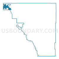
1A-Voting District, Osceola County, Florida
About
Outline

Summary
| Unique Area Identifier | 557336 |
| Name | 1A-Voting District |
| County | Osceola County |
| State | Florida |
| Area (square miles) | 16.67 |
| Land Area (square miles) | 16.67 |
| Water Area (square miles) | 0.00 |
| % of Land Area | 100.00 |
| % of Water Area | 0.00 |
| Latitude of the Internal Point | 28.29370300 |
| Longtitude of the Internal Point | -81.60654500 |
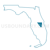
Maps

Graphs
Select a template below for downloading or customizing gragh for 1A-Voting District, Osceola County, Florida


Neighbors
Neighoring Voting District (by Name) Neighboring Voting District on the Map
- 105-Voting District, Polk County, FL
- 113-Voting District (Champions Gate CDD), Osceola County, FL
- 114-Voting District (Indian Creek CFD), Osceola County, FL
- 115-Voting District (Indian Ridge Villas CFD), Osceola County, FL
- 127A-Voting District (Reunion East CDD), Osceola County, FL
- 127B-Voting District (Reunion West CDD), Osceola County, FL
- 127C-Voting District (Reunion Northeast CDD), Osceola County, FL
- 128-Voting District (Stoneybrook CDD), Osceola County, FL
- 129A-Voting District (Enterprise CDD), Osceola County, FL
- 129B-Voting District (Enterprise CDD), Osceola County, FL
- 130-Voting District (Westside CDD North), Osceola County, FL
- 2-Voting District, Osceola County, FL
- 3-Voting District (Celebration CDD), Osceola County, FL
- 4-Voting District, Osceola County, FL
- 5-Voting District, Osceola County, FL
- 97-Voting District, Osceola County, FL
- NBH6-Voting District (Davenport Highway 27), Polk County, FL
Top 10 Neighboring County Subdivision (by Population) Neighboring County Subdivision on the Map
Top 10 Neighboring Place (by Population) Neighboring Place on the Map
Top 10 Neighboring Unified School District (by Population) Neighboring Unified School District on the Map
Top 10 Neighboring State Legislative District Lower Chamber (by Population) Neighboring State Legislative District Lower Chamber on the Map
- State House District 41, FL (252,332)
- State House District 65, FL (179,502)
- State House District 64, FL (165,492)
Top 10 Neighboring State Legislative District Upper Chamber (by Population) Neighboring State Legislative District Upper Chamber on the Map
Top 10 Neighboring 111th Congressional District (by Population) Neighboring 111th Congressional District on the Map
Top 10 Neighboring Census Tract (by Population) Neighboring Census Tract on the Map
- Census Tract 411, Osceola County, FL (16,827)
- Census Tract 410.02, Osceola County, FL (8,388)
- Census Tract 408.03, Osceola County, FL (7,876)
- Census Tract 408.02, Osceola County, FL (5,464)
- Census Tract 125.06, Polk County, FL (4,996)
- Census Tract 124.05, Polk County, FL (4,436)
- Census Tract 408.04, Osceola County, FL (3,932)
- Census Tract 124.06, Polk County, FL (3,899)
- Census Tract 408.01, Osceola County, FL (747)